

A good Chattahoochee trip starts before you ever touch the water. You can roll up to a crowded access point with tubes, snacks, and a loose plan, then realize the river is moving faster than expected, the parking lot is already full, and last night's rain changed the water enough to make the launch a bad call. Exploring the Chattahoochee River: A Complete Guide works best when you treat the river as a live system, not a postcard.
That mindset matters because the Chattahoochee isn't just scenery. It's a managed river corridor, a drinking-water source, a recreation system, and, on some days, a place where the safest decision is to stay off the water. If you read the gauges first, choose the right segment, and respect dam timing, the day gets a lot better.
Table of Contents
- Why the Chattahoochee Demands More Than a Casual Approach
- Understanding the River System and Its Infrastructure
- Reading Flow Data and Water Quality Before You Launch
- Choosing the Right River Segment for Your Activity
- Essential Gear and Safety Protocols for Urban River Trips
- Seasonal Patterns and Wildlife Encounters
- Day Trips and Multi-Day Itineraries with Shuttle Logistics
- Conservation Rules and Local Resources for Responsible Visits
Why the Chattahoochee Demands More Than a Casual Approach
A lot of people arrive at the river on a sunny Saturday expecting a lazy float and a quick photo stop. Then they hit a crowded access point, notice the current is pushing harder than they thought, and realize the day depends on conditions that changed after breakfast. That's the Chattahoochee in real life, especially in metro Atlanta, where the river is as much infrastructure as it is recreation.
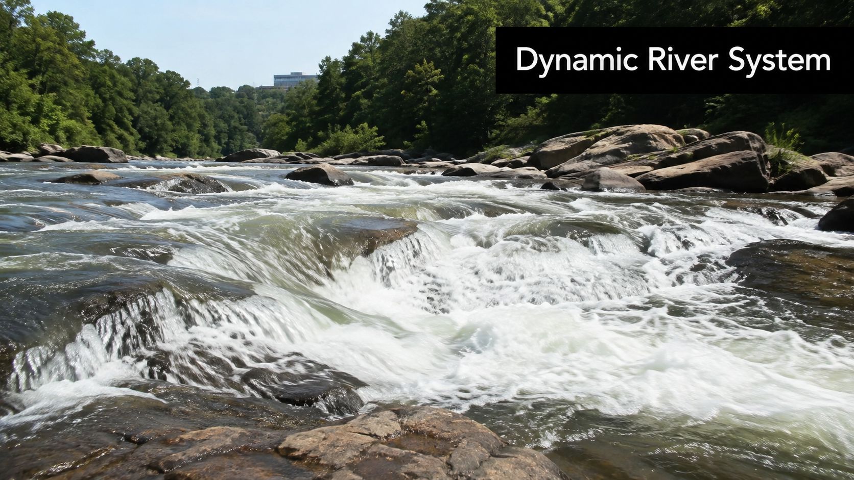
The river changes fast enough to surprise experienced visitors
The Chattahoochee can shift quickly because it's influenced by dam releases, storm runoff, and local tributaries. A low-stress morning near one gauge can turn into a very different downstream experience a few miles later, which is why a casual, one-size-fits-all plan tends to fall apart.
The practical lesson is simple. A river trip here is not just about where you want to go, it's about whether the river is ready for the activity you've picked. If you've ever stood at the bank and felt unsure after checking the water, that hesitation is usually the right instinct.
Practical rule: if you haven't checked the flow, the rain, and the launch conditions, you're not ready to launch.
The river also rewards people who respect its management. Releases, access rules, and bacteria spikes all affect whether a trip is scenic, frustrating, or unsafe. That's why a complete guide needs to lean on real-time conditions instead of only naming pretty spots, including the practical travel context around the river corridor on Atlanta travel guide for first-time visitors.
Understanding the River System and Its Infrastructure
A good river day starts before you leave the house. On the Chattahoochee, the first question is rarely where you want to paddle or fish. It is whether the stretch you picked matches the river's current condition, dam schedule, and water quality.
The Chattahoochee starts in the Blue Ridge Mountains of north Georgia and runs about 434–436 miles to the Georgia-Florida border, where it joins the Flint River to form the Apalachicola River (National Park Service and related references). Along that route it drains 8,770 square miles and helps define the Georgia-Alabama boundary in parts of its lower reach (Chattahoochee Riverkeeper). That scale explains why one part of the river can feel clear and quick while another section runs broader, slower, or more controlled.
For metro Atlanta, the Chattahoochee also functions as working infrastructure. It supplies about 70% of the region's drinking water, or more than 300 million gallons per day, which is why access, conservation, and release timing matter so much (USGS). In practical terms, this is a managed water system first and a recreation corridor second.
Dams, hydropower, and flow variability shape the experience
The basin is regulated by 13 dams and three lock-and-dam facilities, and the University of Georgia River Basin Center also notes 22 hydropower plants in the basin (Georgia Rivers Network). That structure drives most of the day-to-day change people feel on the water. A reach can look relaxed from the road and still run differently once a dam starts releasing.
I read the river by segment, not by assumption. Flow snapshots in the corridor show about 42 cfs at Helen, 636 cfs below Buford Dam, 3,230 cfs near Norcross, and 1,610 cfs below Morgan Falls Dam (Snoflo). Those numbers make the trade-off plain. Upstream water can be thin and technical, while metro reaches may carry enough volume to change speed, strain access points, and alter how comfortable a trip feels.
The river map helps make sense of that spread. 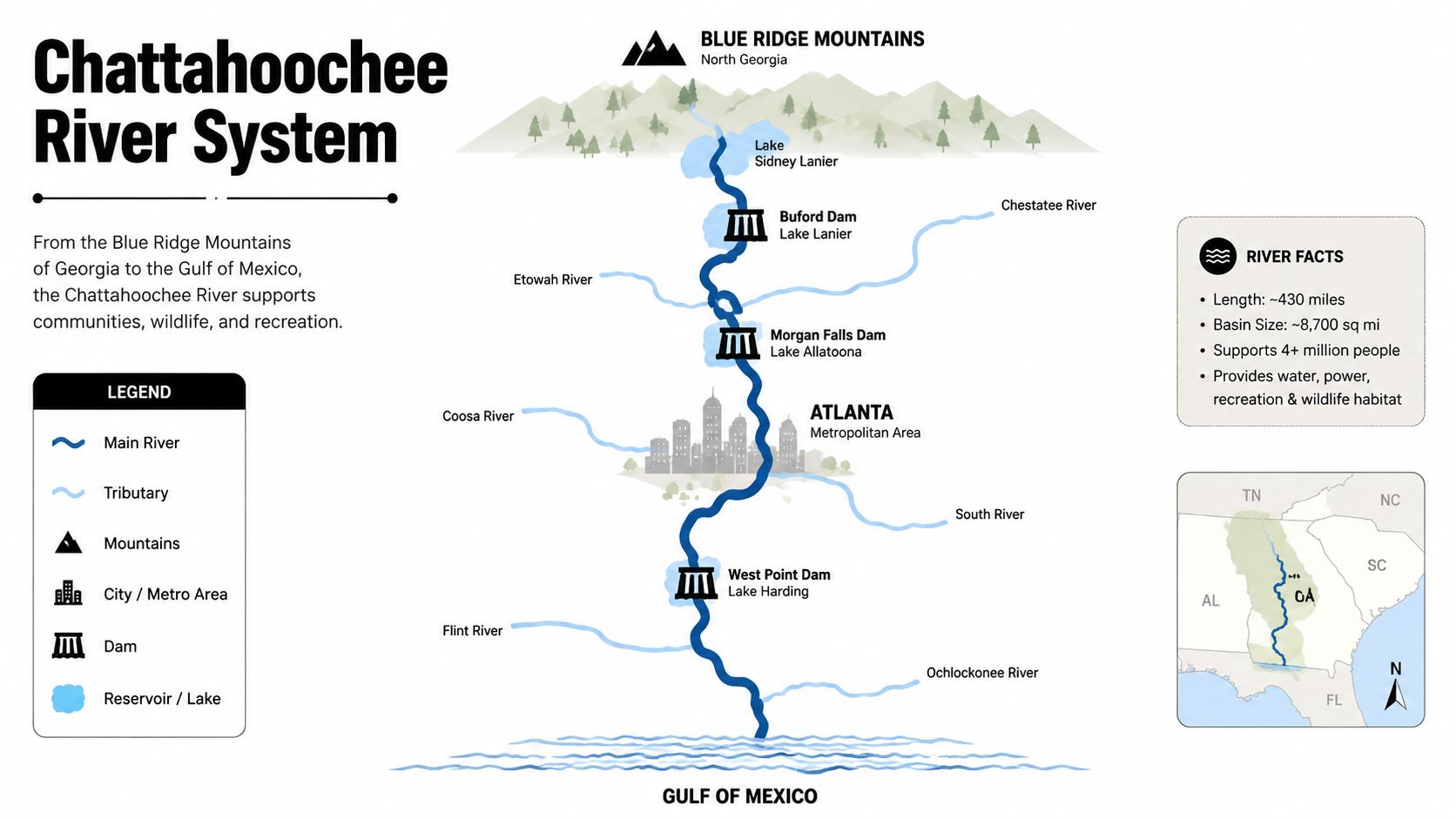
For planning, headwaters, metro reaches, and lower-river segments need different expectations. Release timing, tributary input, and access rules can change the feel of a trip faster than a casual glance suggests. If you want to mix river time with trail time, check the top hiking trails near Atlanta and build your day around the section of river that matches your pace. That same mindset helps with seasonal reading too, which is why a trout water temperature guide is useful when you are deciding whether fish will be active or tucked deep.
Reading Flow Data and Water Quality Before You Launch
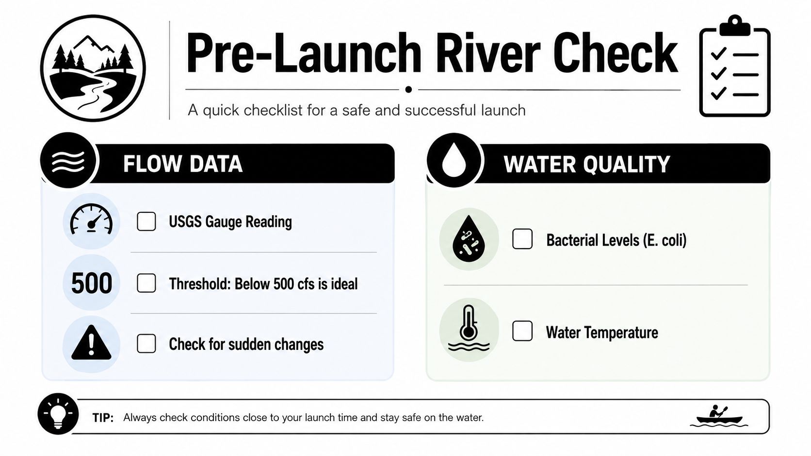
The cleanest launch decisions start at the USGS gauge, not the parking lot. The Atlanta station at USGS site 02336000 has a discharge record that begins in 1928 and water-quality variables with more than two decades of history, so it is useful for both trend checks and same-day calls on the water. On the latest instantaneous reading in the provided data, discharge was 1,610 cfs, water temperature 17.3 °C, specific conductance 97 µS/cm, turbidity 10.3 FNU, and estimated E. coli 450 colonies per 100 mL at that station (USGS inventory).
How to use the numbers without overthinking them
Start with flow. The National Park Service says water-based recreation is not recommended above 8,000 cfs, with tubing suggested below 2,500 cfs, paddling below 4,000 cfs, and most guided trips below 5,000 cfs. Those are practical cutoffs, not decoration. They are the fastest way to tell whether your plan fits the river's current mood.
Then read the water-quality clues. Specific conductance gives a rough sense of dissolved material, while turbidity shows how cloudy the water is. The E. coli estimate matters because fecal-indicator bacteria often rise after heavy rain and can point to a recent contamination pulse, which is why rain forecasts belong in the launch check too.
Check the gauge twice, once the night before and again the morning of launch. Dam releases can change the river quickly, and the Chattahoochee Riverkeeper notes that E. coli levels often rise after heavy rain while releases can push water up fast. If the river has climbed since your first check, switch segments or leave the trip for another day.
For temperature context, the trout water temperature guide is a useful reminder that species, season, and water temperature all shape what the river is doing. Even if you are not fishing, the reading tells you how the water will feel on your body and how quickly conditions can become uncomfortable.
A simple pre-launch sequence that works
- Check the USGS gauge for current discharge, not yesterday's number.
- Compare flow to the activity threshold for the trip you want to run.
- Read recent rain and dam release context before loading gear.
- Look at turbidity and E. coli if swimming, wading, or a family float is part of the plan.
Use the numbers together, not in isolation. A moderate flow can still be a poor choice if bacteria are high or a release is building. The river rewards patience more often than optimism, and that matters even more on urban reaches where access points, current speed, and water quality can change between one check and the next. If you are building a river day around other outings, pair the launch plan with one of these top day trips from Atlanta for families and keep the river segment flexible.
Choosing the Right River Segment for Your Activity
A good Chattahoochee day starts with the segment, not the gear bag. Water level, release timing, access, and parking decide whether the trip feels relaxed or rushed, and the right answer changes with the river's current mood. The protected corridor was created by Congress in 1978 to protect 48 miles of river corridor, with authorization to acquire 10,000 acres and more than 5,000 acres purchased in the latest figures provided. That gives visitors real choices, but the best choice still depends on skill, time, parking, and how much company you want on the bank.
The first question is simple: which stretch fits the day you have?
Chattahoochee River Segment Comparison
| Segment | Difficulty | Ideal Flow Range | Best Activity | Crowd Level |
|---|---|---|---|---|
| Helen headwaters | Easy to moderate | Lower flows | Scenic paddle, short outing | Lower on weekdays |
| Buford Dam reach | Moderate | Controlled releases | Paddling when flow is steady | Varies by release timing |
| Norcross area | Moderate to lively | Mid-range flows | Longer paddles, experienced tubing | Often busier |
| Morgan Falls reach | Easy to moderate | Moderate, manageable flow | Family floats, short launches | Busy on peak weekends |
| East Palisades and nearby access points | Moderate | Conditions-dependent | Hiking plus river viewing | Can fill early |
| Lower protected corridor reaches | Mixed | Segment-specific | Full-day paddling, photography | More variable |
Crowd patterns and parking matter as much as the water
The most popular access points fill first on weekends, especially where trailheads, river views, and easy launches sit close together. Early starts help. So do weekdays, holidays avoided, and access points that ask for a little more walking or a little more planning. That trade-off usually beats showing up late and hoping the nearest lot still has space.
Craft choice changes the whole trip. The discussion in kayaking or canoeing for Lake Bled makes the same point for a calmer setting, and the Chattahoochee puts more pressure on that decision. A shorter float can feel easy in one segment and tiring in another, depending on flow, current speed, and how far the takeout sits from your launch.
For a broader family plan, the routes in top day trips from Atlanta for families can help you pair river time with the rest of the day. Choose the segment that fits your launch window and your tolerance for crowds, then stay flexible if conditions shift.
Essential Gear and Safety Protocols for Urban River Trips
A standard pool float won't cut it on the Chattahoochee. You need gear that handles current, cold water, submerged debris, and the possibility that a dam release changes the river while you're already on it. That's especially true on reaches where reservoir releases can keep the water colder than the air suggests.
The gear that actually earns its place in the boat
Bring a proper PFD, not just something that floats. Add a dry bag for keys, phone, and a spare layer, plus a whistle and a fully charged phone in a waterproof case. If you're paddling rather than wading, a real paddle and a craft that tracks well matter more than a novelty setup.
For board-style outings, choose the right paddle board is useful because stability and board shape matter when conditions aren't perfectly flat. On this river, that choice affects fatigue and control more than most beginners expect.
Cold water can surprise you even when the air feels warm. Dress for the river, not the parking lot.
What to do if conditions change
If you hear a dam release warning siren or get notice that water is rising, move immediately to higher ground and exit the river corridor. Don't try to “beat” the release or finish one more bend. The river doesn't negotiate, and the safest move is always to get out early.
Watch for strainers, especially fallen trees and debris fields that pin a swimmer or boat against the current. Urban sections also carry the usual hidden junk, so keep your line clean, avoid blind corners when possible, and don't assume a shallow-looking stretch is harmless.
The ultimate Atlanta Belt Line guide for visitors and locals is a good reminder that urban recreation works best when you plan transitions, parking, and timing carefully. On the river, that same mindset keeps the day from turning messy.
Seasonal Patterns and Wildlife Encounters
Spring often brings faster water and more change from week to week, so a calm-looking day can shift quickly after rain or a fresh release. Summer usually draws the most visitors to the corridor, which means more boat traffic, more bank users, and less room for error at popular access points. Fall is often the best mix of comfortable air and manageable crowds, while winter can be the quietest season for seeing the river without the usual weekend pressure. Because rainfall and reservoir operations shape conditions, the right month for a relaxed paddle may not be the right month for swimming or a longer float.
What you're likely to notice on the water
Herons are common along softer edges, otters tend to show up in quieter stretches, and bass are part of the river's everyday life. Keep wildlife viewing low-key. Hold your line, give animals space, and treat sandbars and banks as shared habitat, not private observation posts.
Seasonal water quality matters just as much as flow. After heavy rain, bacteria risk rises, so swimming and wading deserve a more careful call than casual riverside hanging. Check current water reports and recent rain before you commit, because the difference between “looks fine” and “good to go” is often what happened upstream a few hours earlier.
Families visiting the corridor can also plan a side trip to nearby family-friendly outdoor attractions in metro Atlanta when river conditions make the water the wrong place to linger. A day beside the Chattahoochee works best when you match the activity to the season, the gauge, and what the river is doing that morning.
The seasonal activity culture at the Chattahoochee Nature Center, from canoe programs to wildlife observation, reflects how much the river changes across the year. Read the season first, then choose the segment and activity that fit it.
Day Trips and Multi-Day Itineraries with Shuttle Logistics
A clean half-day trip starts with a short launch-to-take-out pairing, an early arrival, and a backup plan if parking is tight. For beginners, the best pattern is to launch where the river is easy to access, keep the route short, and avoid planning around peak weekend crowds unless you've already confirmed parking and shuttle options.
Trip styles that are easiest to execute
- Short morning float: pick a straightforward access point, start early, and leave before the midday crowd builds.
- Full-day paddle: choose a segment with stable flow and enough spacing between take-out points to make the trip feel worth the effort.
- Two-car shuttle day: stage one vehicle at the take-out first, then drive to the launch, which removes a lot of end-of-day stress.
- Paid shuttle day: use this when parking, timing, or group size makes two-car logistics awkward.
For route choice, match your timing to the river, not the other way around. If the flow is creeping toward the upper end of the usable range, shorten the trip. If the river is low and slow, choose a tighter segment so the day doesn't turn into a grind.
Multi-day plans need more caution because access coordination matters even more when fatigue enters the picture. Group launches, camping permissions, and take-out timing should all be confirmed before departure, because a changing river can wreck an otherwise good itinerary.
Conservation Rules and Local Resources for Responsible Visits
The Chattahoochee stays usable because people protect it while using it. Inside the National Recreation Area, that means respecting posted rules, leaving no trace, and treating campfires, alcohol, and access points as regulated parts of a shared corridor, not casual free-for-alls. The easiest way to enjoy the river long term is to act like the river belongs to everyone, because it does.
Use the official park maps, current flow updates, and local river stewardship groups before each trip. The Chattahoochee Riverkeeper remains one of the best-known local resources for river health, and the National Park Service maps page is the right place to start when you need segment-specific access information (NPS maps).
If you want to do more than visit, volunteer cleanups and water-quality monitoring programs are the most direct ways to help. They keep the river healthier, and they make future trips better for everyone who launches after you.
If your organization needs a secure, reliable partner for end-of-life electronics, Beyond Surplus handles IT asset disposal, certified data destruction, and responsible electronics recycling for business operations that can't afford loose ends. Visit Beyond Surplus to coordinate compliant pickup, protect sensitive equipment, and keep your next technology refresh under control.


